Enregistrez gratuitement cette image
en 800 pixels pour usage maquette
(click droit, Enregistrer l'image sous...)
|
|
Réf : T01840
Thème :
Terre vue de l'espace - Plaines - Plateaux - Vallées - Général (487 images)
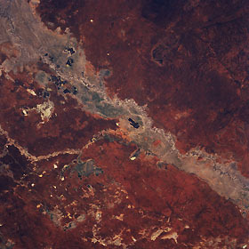
Titre : Darling River, New South Wales, Australia March 1994
Description : (La description de cette image n'existe qu'en anglais)
A small section of the Darling River and its broad floodplain is visible in this northeast view of north central New South Wales. The Darling is the longest river (1700 miles—2736 kilometers) in Australia. On this picture the south draining Warrego (the more narrow floodplain) enters the southwesterly flowing Darling near the center of the picture. The small, dark, rectangular patterns on the Darling floodplain are irrigated croplands, producing mainly citrus fruits and cotton. Overall the region is a semiarid plain, although Mount Gunderbooka (dark feature) at 1629 feet (497 meters) is barely visible southeast of the Darling River (upper right corner). Most of the land elevations range between 350 to 450 feet (107 to 137 meters) above sea level. Several very small dry lake beds (lighter-colored features) can be seen scattered across the terrain north of the Darling.
|
|

